
Iran Is Not One Market: How Geography Shapes Opportunity
The first mistake many outside investors make is to look at Iran as one single market.
It is not.
Iran is a system of regions, corridors, cities, ports, borders, resource belts, industrial clusters, agricultural basins, religious destinations, free zones, and trade routes. A broad view may explain the size of the country, but it does not explain where value is located, how goods move, where capital is decided, which regions carry the most risk, or why one province may become investable long before another.
This is why geography is not a background detail in Iran. It is part of the investment logic.
A software company in Tehran, a warehouse near Bandar Abbas, a petrochemical service provider in Khuzestan, a hotel in Mashhad, a steel-linked manufacturer in Isfahan, a corridor asset in Chabahar, and a regional trading business in Tabriz do not belong to the same opportunity set simply because they are all inside Iran. They depend on different infrastructure, different customers, different labor pools, different authorities, different bottlenecks, and different triggers.
For investors, the practical lesson is simple: Iran cannot be understood only through macro headlines. It has to be mapped.
The question is not only whether Iran is attractive. The better question is where, for which sector, under what conditions, and through which local structure.
Geography Is How Opportunity Works
In some countries, geography is secondary. The main market is concentrated in one city, one financial center, or one industrial corridor. Iran is different. Its economic reality is distributed across several functional regions.
Tehran concentrates decision-making, finance, services, technology, headquarters, and elite consumption. Hormuzgan connects the country to the sea. Khuzestan anchors energy and petrochemicals. Isfahan represents industrial depth and engineering capacity. Razavi Khorasan links Iran to pilgrimage, services, Afghanistan, and Central Asia. Chabahar represents a long-term corridor option toward the Indian Ocean and regional transit. East Azerbaijan connects manufacturing and trade to Turkey, the Caucasus, and northwest routes.
These are not just places on a map. They are different economic functions.
This matters because investment opportunity follows function. Logistics depends on flow. Energy depends on resource location, infrastructure, and contracts. Manufacturing depends on labor, suppliers, power, water, roads, and customers. Tourism depends on access, perception, hospitality standards, and cultural assets. Border trade depends on customs, security, currency conditions, and neighboring markets. Digital infrastructure depends on cities, businesses, payment needs, and commercial density.
The investor who ignores geography may still understand the country’s risk. But they will not understand how opportunity actually appears.
The Map Is a Map of Flows
A serious investor should read Iran as a map of flows.
Capital flows toward Tehran because decision-making, institutions, headquarters, advisory firms, finance, and high-level relationships are concentrated there. Goods flow through southern ports, northwest border routes, eastern crossings, industrial cities, and inland logistics networks. Energy flows through the southwest and the Persian Gulf industrial belt. Pilgrims and service demand flow toward Mashhad and Qom. Minerals and heavy industry concentrate in central and eastern resource-linked regions. Trade routes pull attention toward Hormuzgan, Chabahar, East Azerbaijan, Razavi Khorasan, Kurdistan, Kermanshah, and other border-facing areas.
This way of reading the map is more useful than a simple province-by-province list. It asks what each region does inside the economy.
What moves through this place? Goods, people, energy, capital, data, tourists, pilgrims, minerals, agricultural products, or industrial inputs?
What infrastructure supports that movement? Ports, roads, rail, airports, warehouses, industrial zones, universities, hospitals, border crossings, or digital networks?
What stops the region from reaching higher value? Sanctions, customs, water stress, security, financing, old equipment, weak management, unclear ownership, or poor connectivity?
Those questions turn the map into an investment tool.
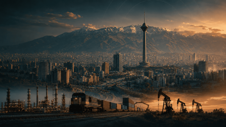
Tehran: The Command Layer
Tehran is the first place many foreign investors encounter, but it should not be mistaken for the whole country.
Its role is coordination. The city concentrates ministries, regulators, financial institutions, corporate headquarters, universities, media, professional services, technology talent, private wealth, and a large consumer market. Even when the asset is located elsewhere, the deal may be introduced, structured, negotiated, financed, or advised through Tehran.
For that reason, Tehran is likely to be the starting point for many early foreign-investor conversations. It is where legal structuring, market intelligence, partner selection, advisory relationships, and high-level commercial access often begin.
But Tehran’s strength can also distort the view. An investor who only sees Tehran may overestimate services and underestimate assets. They may understand decision-making but miss production. They may meet advisors but not operators. They may see consumer demand but not ports, mines, border markets, industrial clusters, or corridor opportunities.
Tehran is therefore best understood as Iran’s command layer: essential for access, structuring, services, consumption, and technology, but not sufficient for understanding where the country’s physical value is located.
The Maritime Gateways: Hormuzgan, Kish, Qeshm, and Chabahar
Iran’s southern geography is central to any serious investment map.
Hormuzgan is the country’s main maritime gateway. Bandar Abbas and Shahid Rajaee Port connect Iran to container flows, imports, exports, customs activity, warehousing, industrial inputs, shipping services, and trade infrastructure. Kish and Qeshm add another layer: tourism, services, maritime positioning, free-zone logic, and Gulf-facing commercial activity.
If Iran’s external trade environment improves, the first signals may appear in the south. Not in speeches, but in movement: cargo volumes, port services, insurance access, container handling, bonded storage, trucking, cold chain, freight forwarding, and customs reliability.
Chabahar is different. It is not simply another port. Its logic is strategic optionality.
Located on the Gulf of Oman, outside the Strait of Hormuz, Chabahar has long been discussed as a potential corridor connecting Iran, India, Afghanistan, Central Asia, and wider regional trade routes. Its full value depends on infrastructure, rail and road connections, customs capacity, security, regional agreements, sanctions treatment, and long-term trade volume.
Bandar Abbas is an existing trade machine. Chabahar is a future corridor thesis.
That difference matters. Hormuzgan is where investors watch current maritime activity. Chabahar is where they watch long-term geo-economic possibility. Both are important, but they do not carry the same timing, risk, or investment logic.
The Energy and Industrial Southwest: Khuzestan and Bushehr
Khuzestan is one of Iran’s deepest economic provinces because it combines energy, petrochemicals, agriculture, water, industry, and access toward Iraq.
Its importance is not limited to oil. Oil is the base, but around that base sits a wider industrial system: refineries, petrochemicals, pipelines, power, maintenance, industrial services, logistics, downstream processing, and export-linked activity. If Iran’s energy trade, petrochemical exports, or industrial services improve, Khuzestan becomes one of the first regions to study.
Bushehr adds another layer to the southern industrial belt, especially through gas, petrochemicals, maritime energy infrastructure, and the wider role of the Persian Gulf economy. Together, Khuzestan and Bushehr show that energy investment is not only about fields and reserves. It is about the ecosystem surrounding them.
But these provinces also show why geography is a risk map.
Energy regions are often politically sensitive. Environmental issues, water stress, labor concerns, infrastructure pressure, local grievances, sanctions exposure, and contract complexity can all affect investment outcomes. A project that looks attractive through an energy lens may become much more complicated through a local governance lens.
In this part of Iran, the upside is real, but the margin for superficial analysis is low.
The Industrial Core: Isfahan, Yazd, Kerman, Markazi, and Qazvin
Iran’s industrial geography is not limited to one province.
Isfahan is one of the clearest expressions of Iran’s industrial base: steel, machinery, engineering services, construction materials, technical labor, universities, and manufacturing networks. It is also a reminder that industrial strength must be read alongside environmental constraints, especially water stress and energy use.
Yazd and Kerman add a different industrial logic: minerals, metals, desert industry, resource-linked production, energy-intensive activity, and manufacturing connected to central and eastern Iran’s physical geography. Kerman in particular matters for mining and mineral-linked opportunities, while Yazd is often associated with industrial production in a harsh but commercially adaptive environment.
Markazi and Qazvin are important because of their proximity to Tehran and their manufacturing base. They sit closer to the country’s demand and decision-making centers while offering industrial capacity, logistics access, and production sites that may be more practical than the capital itself.
These regions matter because Iran’s industrial opportunity is not about building production from nothing. Much of the base already exists. The question is which assets can improve through machinery upgrades, quality control, working capital, export standards, energy efficiency, procurement systems, and better management.
Industrial Iran is not one place. It is a belt of capabilities.
The Eastern Interface: Razavi Khorasan and the Afghanistan–Central Asia Link
Razavi Khorasan has a different investment logic from the south or the industrial center.
Mashhad is a major urban market, a religious destination, a healthcare and services center, and a gateway toward Afghanistan and Central Asia. The province combines pilgrimage, hotels, food, retail, transport, healthcare, education, border trade, and agricultural processing.
Its opportunity is not primarily maritime, and it is not mainly energy. It is an eastern interface.
If Afghanistan becomes more commercially stable, if Central Asian routes become more active, or if regional trade through the east improves, Razavi Khorasan could gain importance as a services and logistics platform. Its religious and cultural links also create flows of people that are not easily replaced by another city.
This region shows a broader point: borders are not only edges. In Iran, several borders are market interfaces. They connect local demand to neighboring economies, informal networks, trade habits, ethnic ties, transport routes, and service flows.
For investors, the question is whether those connections can be organized into modern businesses: logistics, warehousing, payments, healthcare packages, food exports, hotels, border services, and regional distribution.
The Northwest Interface: East Azerbaijan, Aras, Maku, and Tabriz
East Azerbaijan and Tabriz represent Iran’s northwest commercial and manufacturing interface.
Tabriz has a long trading history, industrial culture, food industries, machinery, manufacturing, and proximity to Turkey, Azerbaijan, Armenia, the Caucasus, and wider Eurasian routes. This gives the region a different profile from Tehran, Hormuzgan, or Khuzestan. Its strength is not central coordination, maritime access, or energy. Its strength is cross-border commercial logic and manufacturing familiarity.
Aras and Maku free zones add another layer because they sit near important border routes. Their value depends on whether they can reduce friction in trade, warehousing, customs, re-export, industrial activity, or regional access. As with all free zones, the legal label is not enough. The question is whether the zone solves a real economic problem.
If Iran’s trade access improves, the northwest could become more important for export-oriented manufacturing, food processing, components, regional distribution, and trade services. But its potential depends on customs efficiency, transport infrastructure, currency conditions, and political relationships with neighboring markets.
The northwest is not a peripheral region. It is one of Iran’s commercial interfaces with the outside world.
Demand and Service Centers: Mashhad, Isfahan, Shiraz, Tabriz, and Tehran
Not every regional opportunity is about ports, energy, or factories.
Iran also has major demand and service centers. Tehran is the largest, but it is not alone. Mashhad, Isfahan, Shiraz, Tabriz, Karaj, Ahvaz, Qom, and other large cities create demand for healthcare, education, housing, retail, food, transport, financial services, entertainment, and digital tools.
This matters because consumer and service opportunities are not distributed evenly. A healthcare platform, education business, retail chain, hotel operator, restaurant group, or digital service may scale differently depending on city density, income patterns, tourism flows, local culture, and transport access.
Shiraz, for example, has cultural, medical, agricultural, and tourism relevance. Mashhad combines pilgrimage with services and hospitality. Isfahan combines heritage with industry. Tabriz combines urban demand with trade culture. Qom has religious and education-linked flows. Tehran has the deepest concentration of capital and consumption, but also the highest competition and cost.
A geographic view prevents investors from making lazy consumer assumptions. Iran has one population, but not one consumer pattern.
Free Zones Are Interfaces, Not Magic
Iran’s free zones are often presented as shortcuts to opportunity. That is the wrong way to read them.
A free zone is useful only if it reduces a real friction: customs, warehousing, foreign ownership, tax treatment, re-export, tourism, industrial clustering, border trade, port access, or services. If it does not solve a real economic problem, the label itself has little value.
Each free zone must therefore be read by function.
Kish and Qeshm are tied to Gulf services, tourism, trade, maritime positioning, and commercial access. Chabahar is a corridor and ocean-access thesis. Aras and Maku connect to northwest trade, Turkey, the Caucasus, and Eurasian routes. Anzali faces the Caspian logic, with relevance to Russia, the Caucasus, and Central Asia. Arvand sits near Iraq and the southwest energy-trade environment.
The investment question is not “Is this a free zone?”
The better question is what the zone actually enables. Does it have real activity? Does it have infrastructure? Does it connect to a trade route? Does it reduce customs friction? Can foreign investors own or operate clearly? Can goods move? Can capital move? Are local authorities effective? Are there credible partners?
Free zones can matter, but only when the legal framework meets an economic function.
The Map Is Also a Risk Map
Geography reveals opportunity, but it also reveals the risks that broad analysis hides.
Water stress matters more in some provinces than others. Border security matters in the east, west, and southeast. Maritime disruption matters in the south. Environmental pressure matters in industrial and energy regions. Local ownership structures can be more difficult in certain areas. Labor availability, local politics, infrastructure quality, land status, and regulatory enforcement can vary sharply by region.
This means a sector can be attractive in one place and weak in another.
A logistics project may work near a real corridor and fail near an imagined one. A tourism asset may be beautiful but unreachable. A manufacturing plant may have demand but face water or energy constraints. A border business may depend too heavily on unstable neighboring conditions. A free-zone project may look attractive legally but lack actual throughput.
This is why a map is not only a discovery tool. It is a filter.
It helps investors avoid the wrong version of a good idea.
If Iran Opens, Geography Will Decide the Sequence
If Iran becomes more accessible to foreign capital, trade, and technology, opportunity will not move evenly across the country.
The first changes are likely to appear where existing activity is most sensitive to access.
Ports and logistics could respond early because trade flows can change quickly when shipping, insurance, banking, and customs conditions improve. Energy services and petrochemicals may respond where export channels, equipment, and industrial contracts become easier. Manufacturing regions may benefit when machinery, trade finance, standards, and regional buyers become more accessible. Tourism may respond where perception, flights, payments, and hospitality standards improve together. Digital infrastructure may grow where businesses need systems to support more open commercial activity.
In other words, the map will not simply show where opportunity is located. It will show the order in which opportunity may become investable.
This is one of the most important reasons to study Iran region by region. Timing is geographic. A corridor can move before a consumer market. A port can reprice before an inland factory. A hotel cluster can recover before a mining project becomes financeable. A border region can become active because of one neighboring market while another region remains quiet.
Investors who understand sequence will read change earlier.
How Hormuz.Group Reads the Map
Hormuz.Group should not map Iran as a collection of tourist facts or administrative provinces.
The useful map is an investment map.
For each province or free zone, the important questions are practical: what is the region’s economic function? Which sectors matter? What assets are strategic? What infrastructure exists? Which corridors connect it to other markets? What bottlenecks limit value? What risks are local rather than general? Which triggers would make the region more investable? Which partners, operators, projects, and institutions require verification?
This is the reason province pages matter.
A serious investor does not only need to know that Khuzestan has energy, Isfahan has industry, Hormuzgan has ports, or Mashhad has pilgrimage. They need to know how those features translate into investable conditions. They need to understand the local structure behind the headline.
The map should therefore become a research gateway. A user should be able to move from a province to its industries, from an industry to its bottlenecks, from a bottleneck to potential opportunities, and from an opportunity to the trust questions that determine whether it can be executed.
That is how geography becomes intelligence.
Iran Is Not One Market
Iran’s opportunity cannot be understood through a single story.
It is a portfolio of regional functions. Tehran coordinates. Hormuzgan connects to the sea. Khuzestan anchors energy. Isfahan, Yazd, Kerman, Markazi, and Qazvin carry industrial and mineral-linked capacity. Razavi Khorasan opens toward the east. Chabahar holds corridor optionality. East Azerbaijan connects manufacturing and trade to the northwest. Free zones operate as interfaces only when they solve real frictions. Demand centers create consumer and service markets that vary by city.
This does not make Iran simple. It makes it readable.
The investor who looks at Iran only as one market may understand the headline risk, but they will miss the structure of opportunity. The investor who reads the country by region, function, flow, bottleneck, and trigger will see a much clearer picture.
At Hormuz.Group, geography sits at the center of the research approach because Iran is not just a market to be described. It is a market to be mapped.
The better question is not “Is Iran attractive?”
It is: where does Iran become investable, for which sector, under what conditions, and through whom?